
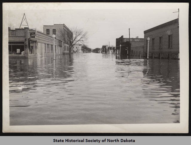
Mandan ND Business district at height of flood, March 1943.
Rebecca Sabot, Real Estate Agent (RE/MAX Capital) — full-time Realtor serving Bismarck–Mandan.
© Rebecca Sabot. All rights reserved.
If you live anywhere near the Missouri River in Bismarck–Mandan, you’ve probably wondered: is flooding a “once in a lifetime” thing… or a “not again, please” thing?
The honest answer is: it depends on what you mean by “flood.” Some years bring minor flooding or high water, while truly major, neighborhood-changing floods are much rarer.
The Simple Answer
1) Minor flooding: can happen in some years (especially with ice)
The National Weather Service defines Minor Flood Stage in Bismarck as 14.5 feet.
When the river is dealing with ice formation/ice jams, water levels can rise quickly and cause localized issues even without a classic “big flood.”
2) “Flood stage” level events: roughly once a decade (based on historic peaks)
Using the USGS annual peak gage-height record for the Missouri River at Bismarck, years that get up into flood-stage territory (around/above that minor-flood threshold) show up occasionally—not constantly. A quick read of the long-run peak list shows about ~10 years with peaks at/above roughly that level over most of the measured record (mid/late 1920s through 2024), which works out to about once every ~9–10 years on average.
Important: averages are useful, but floods don’t show up on a tidy schedule. They “cluster” and then disappear for a while—like that one friend who only texts when they need a ride to the airport.
3) Major, headline-level flooding: rare, but it has happened
Bismarck has seen truly memorable high-water events. For example, 2011 was a major year (with the river cresting around 19.25 feet in the area per local reporting).
And historically, the USGS peak record shows 1952 as an extreme outlier year (very high peak flow).
What Causes Missouri River Flooding Here?
In Bismarck–Mandan, the big drivers are usually:
Reservoir releases and basin-wide runoff. The Missouri is heavily managed upstream, so large volumes and releases can matter a lot (2011 is the classic example).
Spring snowmelt + rain timing. When melt and rain stack up, that’s when rivers get spicy.
Ice jams and freeze/thaw swings. These can cause quick water rises and localized flooding impacts.
Flood Risk Isn’t Equal Everywhere (Even on the Same Street)
This is the part most people miss: “near the river” is not the same as “in a floodplain.”
Floodplain mapping typically talks in terms like 1% annual chance flood (often called the “100-year flood”) and 0.2% annual chance flood (“500-year flood”). Those terms describe probability, not a countdown timer.
If you’re unsure, the City of Bismarck and Burleigh County both point residents to flood mapping resources and floodplain info for property-specific questions.
Practical Takeaways for Homeowners and Buyers
If you’re buying near the river: ask for the property’s flood zone, any prior flood history, and whether flood insurance has been carried before.
If you already own near the river: know your elevation, pay attention to spring outlooks, and don’t assume “it hasn’t flooded since…” means it won’t. (Rivers love proving us wrong.)
If you’re outside the mapped floodplain: you can still flood. Maps are essential tools—but Mother Nature does not read them.
Summary
Minor flooding/high water: can occur in some years (ice can be a culprit).
Flood-stage type events: about once every decade on average using historic peak patterns.
Major flooding: rare, but real (2011 is the modern reference point).
If you want, I can help you sanity-check a specific address the smart way: flood zone + elevation context + resale considerations (not vibes, not rumors, not “my cousin said”).
—Rebecca Sabot
© Rebecca Sabot. All rights reserved.